HISTORY OF NEGRIL JAMAICA
|
|
The name "Negril" is a shortened version of "Negrillo," as it was originally named by the Spanish in 1494. The name is thought to be a reference to the black cliffs south of the village. Although Negril has a long history, it did not become well known until the second half of the twentieth century.
Negril's development as a resort location began during the late 1950s, though access to the area proved difficult as ferries were required to drop off passengers in Negril Bay, forcing them to wade to shore. Most vacationers would rent rooms inside the homes of Jamaican families, or would pitch tents in their yards. The area's welcoming and hospitable reputation grew over time and the first of many resorts were constructed in the mid to late 1960s.
When the road between Montego Bay and Negril was improved in the early 1970s, it helped to increase Negril's status as a new resort location. It was a two-lane paved road that ran approximately 100 yards inland from two white coral sand beaches, at the southern end of which was a small village. The long paved road from the village ran north to Green Island, home to many of the Jamaican workers in Negril, and was straight enough to double as a runway for small airplanes, which was why there were lengths of railroad track standing on end along the side of the road - to discourage drug smugglers from landing on the road to pick up cheap cargos of marijuana.
|
|
After Negril's infrastructure was expanded, anticipating the growth of resorts and an expanding population, a small airport was built in 1976 near Rutland Point, alongside several small hotels mostly catering to the North American winter tourists. Europeans also came to Negril, and several hotels were built in order to cater directly to those guests.
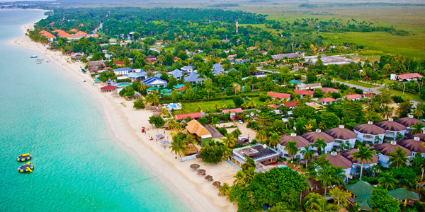
The geography of Jamaica is quite diverse. The western coastline contains the island's finest beaches, stretching for more than six kilometers along a sandbar at Negril. It is known as the "7-Mile Beach" although it is only slightly more than 4 miles (6.4 km) in length, from the Negril River on the south to Rutland Point on the north.
On the inland side of Negril's main road, to the east of the shore, lies a swamp called the Great Morass, through which runs the Negril River, amidst which is the Royal Palm Reserve, with wetlands that are protected since they are responsible for the growth of crops in the region, which upon death, begin to decay, helping to form coral sand along the beachfront. In 1990, the Negril Coral Reef Preservation Society was formed as a non-profit, non-governmental organization to address ongoing degradation of the coral reef ecosystem. The Negril Marine Park was officially declared on March 4, 1998 covering a total area of approximately 160 square kilometers and extending from the Davis Cove River in the Parish of Hanover to St. John's Point in Westmoreland.
|
|
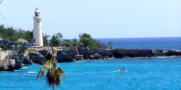
Scuba Diving and snorkeling are especially good in the protected reef areas. The West End Road is also known as Lighthouse Road as there is a Belgian engineered lighthouse protecting seafarers from the dramatic cliffs. There is beautiful scenery on the western tip of Negril, near Negril Point Lighthouse. You can mingle with locals at beer shacks like Sexy Rexy's and others "out West".
For years, Negril's beach has been rated as one of the top ten beaches in the world by many travel magazines. The north end of the beach is home to the large, all-inclusive resorts, and to the south are the smaller, family-run hotels. This combination gives the Negril area a large variety of rooms, services and prices. South of downtown Negril is West End Road, known as the cliff area, which is lined with resorts that offer more privacy. These areas offer easy access to waters good for snorkeling and diving, with jumping points reaching more than 40 feet (12 m) high.
Rick's Cafe is a place to watch the cliff jumpers, although there have been a number of fatalities and serious injuries with regard to visitors attempting even the lower level jumps (rock impacts, paralysis/quadriplegia, ear drum impaction etc..) Rick's is considered one of the 1,000 places to go before you die. Although most of Rick's was destroyed, and slid into the ocean in the hurricane of 2003, it has been rebuilt rock sturdy. Its sunsets are still some of the best in the world.
|
|
That Negril is still fairly underdeveloped remains a significant factor in its undoubted charm. This may not last, as a new highway from Montego Bay and an improved infrastructure may bring more tourists. In recent years it has also become a popular location for U.S. college students to visit during spring break.
The larger hotels such as Hedonism II, Couples, and Grand Lido, as well as some smaller hotels offer "au naturel" bathing areas, which has made Hedonism II particularly the most revisited resort in the Caribbean, if not the world. Lifestylers,(swingers), also flock to Hedonism to partake in a no-holds barred sexual freedom, reminiscent of the earlier hippy beginnings of Negril in the 1960s. Some say Hedonism has fueled the "au naturel" all-inclusive vacations that are now prominent in the Caribbean, and resorts such as Desires in Mexico. The availability of many drugs, illicit and drugs such as Viagra, adds fuel to the "sexual revolution".
The last few years have seen major development along the famed "Seven Mile Beach" The resorts include Couples Swept Away, Couples Negril, Sandals, Beaches, Samsara Hotel, Legends Resort, Grand Lido, Riu Club Hotel and Hedonism II. A branch of Jimmy Buffett's chain restaurant and bar, Jimmy Buffett's Margaritaville, and a duty free zone have also been added. These developments have led to adverse environmental effects e.g. dredging of sea grass beds caused the major loss of beach area due to increased sea water erosion.
|
|
|


